

This morning, New York City woke up to its first snow of the season – a thin veil of fluffy white that melted almost as soon as it touched the pavement. The flurries are a reminder that winter has officially arrived!
Across the five boroughs, residents reported light flurries between 7 a.m. and 10 a.m, and even spotted on and off in the afternoon. The brief dusting came alongside temperatures dipping into the upper 30s, with wind chills making the city feel closer to freezing.
What Caused Today’s Flurries
The first snow was triggered by a polar-vortex-driven Arctic blast sweeping down the East Coast, according to the New York Post. That same cold surge put the tri-state area under a freeze warning Tuesday morning, with overnight lows expected to hit the 20s in northern suburbs.
While accumulations were negligible, the event is a marker in meteorological terms, the first snow of the 2025-26 season. A not-so-subtle transition from late autumn to the coming winter season.
Will we Have a White Winter?
Turning from today’s flurries to the coming winter months, the outlook for 2025-26 leans toward “milder and somewhat drier” for New York City, but with caveats.
Some forecasts points to a total of 15-20 inches of snow this season, compared with he 30-year historical average of about 25-30 inches. With a weak to moderate La Niña pattern that is expected to affect the jet stream, makes predicting more complex. Although, what we can expect for sure is an overall milder temperature, and possible spikes of cold and stormy weather.
Meteorologist stress that a “mild winter” is not necessarily a snow-free one. One or two heavy storms (even nor’easters) still remain plausible.
A Glance back
In decades past, New York had winters that routinely brought more snow and deeper white blankets. According to data compiled by Extreme Weather Watch, the snowiest winter on record for New York City was the 1995-1996 season, when the city recorded 75.6 inches of snowfall.
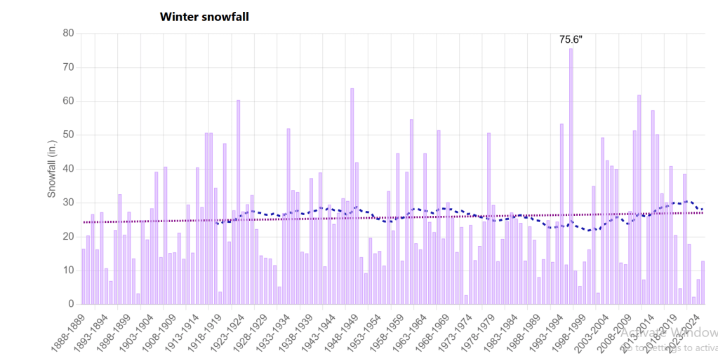
In this decade, the city averages close to 30 inches of snow per winter. Historically, winter includes multiple storms, deeper accumulation, and longer periods of snow cover. Local hazard-profiles note a trend of more “days without accumulating snow” along with declining days below freezing, highlighting changes in winter hazard patterns.
In effect, winters have become less reliably white. The flakes may still fly, but the broad, shovel-and-sled winters feel rarer.
It is Getting Hotter
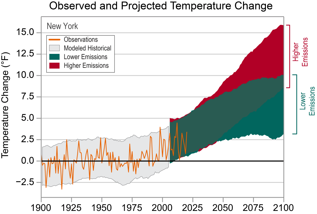
According to NOAA climate data, New York’s average winter temperature has risen roughly 2.5 °F over the past 50 years, but snowfall patterns remain erratic with less frequent, yet unpredictably intense.
With the warmer coast weather, and any cold fronts from land can result in nor’easters. Which can explain the rising intensity of extreme winter storms. With temperatures predicted to continue to increase due to emissions, we can only expect for weather to become dramatically different from the years before.
How NYC Is Preparing
The city’s Department of Sanitation (DSNY) has already rolled out its “first line of defense” salt-spreader trucks, prepping highways and major routes for the season ahead.
For city infrastructure, even light snow can test systems – from road salt supplies to subway track heaters. Urban ecologists note that the timing of early snowfalls affects plant dormancy, migratory bird patterns, and urban heat-island dynamics, as trees drop their leaves and cooler air alter how the city retains heat overnight.
What It Means for New Yorkers
For most, today’s flakes meant nothing more than a chilly commute and a moment of seasonal wonder. For meteorologists and scientists, it was data – an early entry in a long notebook tracking how the Northeast’s climate is evolving.
Whether this winter brings the need of a light puffer coat or a few headline-grabbing nor’easters, New Yorkers will adapt as they always do: boots by the door, salt on the stoop, eyes to the sky.
